
Drone Mapping & Specialized Imaging
Get the information your next decision depends on.
When your project needs more than a visual overview, start with the question you need answered. You may need to understand terrain before development, document building systems before walls close, or compare changes across land or facilities. Depending on your project, we assess requirements for orthomosaic mapping, LiDAR terrain data, photogrammetry, stockpile volume estimates, thermal or multispectral imagery, and 3D scanning. Capture may be aerial, ground-based, or both.
You bring the project need. We help define the scope, assess suitable specialist providers, and coordinate accepted assignments through delivery. Specialist availability, qualifications, methods, and deliverables are confirmed before we accept the work.
Based in Peachtree City, with specialty-project inquiries considered throughout Georgia and other areas of the Southeast.
Discuss your specialty projectStart with your goal
Tell us what you need to find out.
You don’t need to know which equipment or specialist to ask for. Tell us what you need to learn about your site, building, or land—and how that information will help your project. If your engineer or project team has specific requirements, we can start there.
We help clarify what’s needed and assess specialists suited to the work. Before you commit, we confirm the proposed approach, the provider’s qualifications, and what you’ll receive. For projects we accept, La Strada coordinates the work and remains your point of contact through delivery.
Explore the project categories further down this page, or tell us about a need that isn’t listed.
01 / Site planning & development
Understand the site before the next decision.
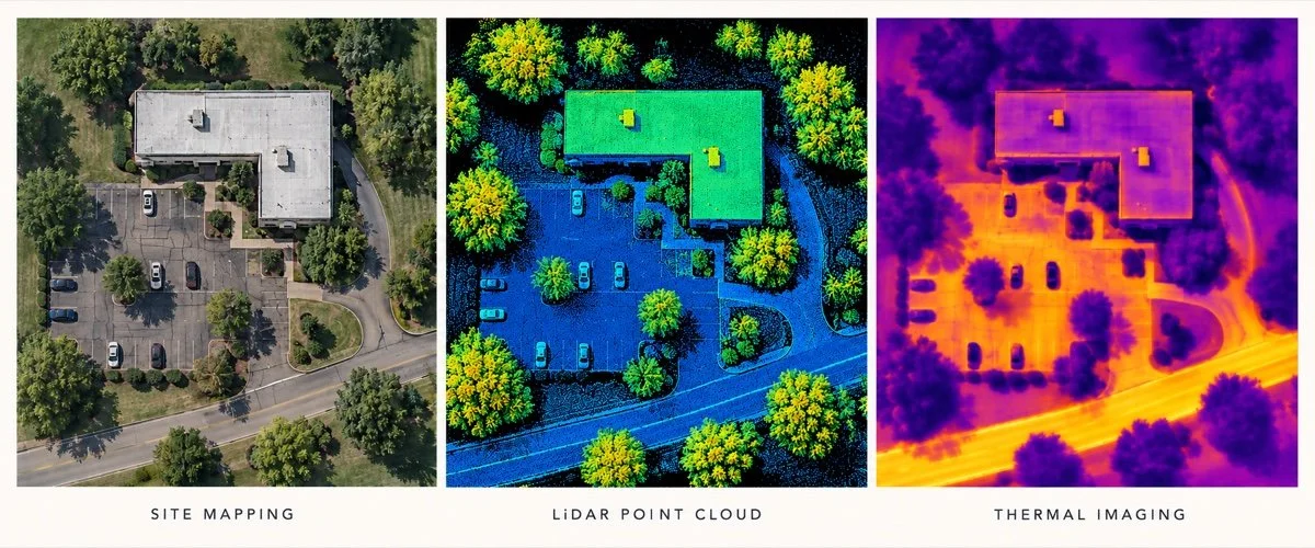
Bring together the surface, structures, and changes that matter to a development or construction project.
Drone Orthomosaic Mapping
Give your team a current, detailed view of the whole site. Overlapping aerial photographs are combined into a geometrically corrected overhead map, with coverage and detail planned around your project.
- Give builders and subcontractors a shared site map for coordinating work areas and access.
- Compare maps from different dates to review visible changes in clearing, grading, and construction.
LiDAR Mapping & Terrain Data
Understand the shape of the land before planning what comes next. Specialist laser capture produces detailed elevation and terrain information, with the method and coverage suited to the site and your team’s requirements.
- Help an engineer review slopes and drainage before a site expansion.
- Provide terrain information for a qualified project team evaluating a wooded development parcel, where site conditions allow.
Photogrammetry & 3D Site Models
See how buildings, roads, and other site features fit together. A photographic 3D model or mapped feature layers can help your team explore the site’s layout and explain it to others.
- Help a renovation or expansion team understand existing buildings, access routes, and surrounding features.
- Give owners and stakeholders a model they can explore during a site-planning presentation.
Stockpile Volumes & Earthwork Measurements
Understand how much material is on site and what has changed between visits. Photogrammetry or LiDAR capture and specialist processing can support stockpile volume estimates and cut-and-fill comparisons, using an agreed baseline or reference surface. Required accuracy, checks, and deliverables are confirmed for your project.
- Track soil or gravel stockpile volumes between visits to support material planning.
- Compare captured ground surfaces to help a contractor review earthwork progress against an agreed baseline.
Have a large property or existing aerial photographs? We can assess coverage and processing needs, along with any ground-control or accuracy requirements. Where measured reference points or independent checks are needed, we coordinate qualified support as part of the agreed scope.
02 / Buildings, facilities & infrastructure
Know more about the assets you manage.
Whether you’re planning maintenance, preparing a renovation, or investigating a concern, get a clearer view of the building or structure involved. Capture and any specialist assessment are planned around the questions your team needs answered.
Thermal imaging & asset documentation
Give your inspection or maintenance team more information about areas that need attention. Specialist thermal and visual capture can document temperature patterns and visible conditions, with interpretation assigned to the appropriate qualified professional.
- Help a qualified roof inspector identify temperature patterns that warrant closer investigation.
- Provide thermal and visual records of solar panels or electrical equipment for a specialist’s maintenance review.
Interior scanning & digital twins
Give your team a detailed record of the spaces they need to work with. Specialist scanning can document interior layouts and structural features in a 3D model, with the detail and file formats planned around renovation, maintenance, or a broader digital-twin project.
- Help a renovation team understand an existing commercial or industrial space before planning changes.
- Document visible plumbing, wiring, and framing before walls or ceilings are closed, giving the project team a record to consult during future maintenance or renovations.
Confined-space & difficult-access capture
Get a clearer view of areas that are difficult to document through conventional access. We assess specialist equipment and operators suited to the structure, access restrictions, and information your inspection team needs.
- Document the interior of an industrial tank or enclosed structure for review by a qualified inspector.
- Capture hard-to-reach areas of a facility or structure to help a maintenance team plan a closer assessment.
03 / Agriculture, livestock & land stewardship
Understand what’s changing across your land.
Get a broader view of the fields, pastures, and woodland you manage. Capture can help your team identify areas to investigate, plan an on-the-ground visit, and follow changes over time, with specialist interpretation where needed.
Multispectral imaging & crop monitoring
Help your crop adviser identify areas that deserve a closer look. Specialist imagery records differences in vegetation that may be difficult to recognize across an entire field from the ground, helping guide further checks rather than assuming a cause.
- Help an agronomist locate areas of uneven crop growth and prioritize field checks.
- Compare imagery from different dates to help a crop adviser review changes in vegetation after irrigation or management adjustments.
Livestock location & counting
Help locate animals across your property and support a review of herd numbers. Aerial or thermal capture may assist where animals are visible and distinguishable, with the approach planned around vegetation, site conditions, and animal welfare.
- Help a livestock owner locate animals across open pasture and identify areas that need an on-the-ground search.
- Support a herd count from captured imagery, with obscured areas and uncertain counts flagged for follow-up.
Forestry & land monitoring
Keep a clearer record of changes across woodland, pasture, and restoration areas. Planned aerial coverage can document visible storm impacts, erosion, and vegetation changes so your team knows where to focus its next site visit.
- Document visible storm damage across woodland or rural property to help prioritize access checks and cleanup.
- Revisit an eroding drainage route or restoration area to track visible changes and help plan follow-up work.
04 / Water & environmental questions
Get a clearer picture of conditions you need to understand.
Whether you’re managing a pond, investigating potential emissions, or evaluating changes across a site, start with the question you need answered. We assess suitable specialists and capture methods to help your team plan its next steps.
Bathymetry
Understand what lies beneath the water before planning maintenance or improvements. Specialist depth mapping can document the bottom of a pond, basin, or reservoir, using a method suited to the water and site conditions.
- Help a property manager or engineer assess pond depth and sediment buildup before planning maintenance.
- Compare surveys over time to help a qualified team understand changes in a basin’s available water-storage capacity.
Methane detection
Help your environmental or operations team identify areas that need closer investigation. Specialized sensors can detect methane and map observations across a site, with results interpreted by qualified specialists.
- Help a landfill operator identify potential emission areas and prioritize on-the-ground checks.
- Revisit previously flagged areas to support a specialist’s follow-up assessment after corrective work.
Hyperspectral imaging
Help your environmental team investigate differences in vegetation or surface materials that ordinary photographs may not reveal. Specialist sensors record detailed patterns of reflected light, providing information to guide analysis and field checks.
- Help a restoration team distinguish vegetation types and assess changes across a managed site.
- Map differences in exposed soil or surface materials to help an environmental specialist prioritize field sampling.
05 / Scale, access & project requirements
Plan around your project’s requirements.
A large site, restricted access, or specific equipment requirements can change how a project needs to be approached. Share those details early so we can assess suitable providers, capture methods, and data-handling arrangements before preparing a proposal.
Large sites & complex access
Find an approach suited to the area you need covered and the places your team can access. We assess whether conventional drones, specialist fixed-wing drones, or crewed aircraft could meet the project’s needs, subject to site conditions and operating requirements.
- Assess coverage options for a large rural property or development site where the team needs a view of the entire area.
- Plan capture along a road or utility corridor where distance and limited ground access affect how the work can be completed.
Specified equipment & data requirements
Establish whether a proposed provider and workflow can meet your organization’s requirements before committing to the work. These may include Blue UAS-listed aircraft, other specified equipment, or conditions governing where project data is stored and who can access it.
- Review a public-sector project’s specified aircraft and provider requirements before preparing a proposal.
- Assess a facility owner’s requirements for storing, accessing, and delivering imagery of a restricted site.
From the first question to delivery
A clear plan.
A coordinated project.
Tell us what you need.
Share the location, the questions you need answered, and when you need the results. Include any site-access restrictions or requirements from your project team.
Find the right approach.
We assess suitable specialists, equipment, and analysis, then clarify what the work can deliver and any limitations before you commit.
Agree on the plan and quote.
Confirm what is included, who is responsible, the price, and the delivery schedule—including the file formats and how you plan to use the results.
Coordinate the work and delivery.
La Strada remains your point of contact, coordinates the agreed work, and arranges delivery with any specialist explanation or follow-up included in your quote.
Practical questions
What to know before we begin.
I’m not sure which service I need. Can you help?
Yes. Tell us what you need to find out about the property, building, or site and how you plan to use the information. You don’t need to choose a sensor or technical service first. If your engineer or project team has requirements, we can start with those.
Who handles my project and the specialist work?
La Strada Aerials remains your point of contact for an accepted project, coordinating the agreed work, updates, billing, and delivery. Qualified specialists handle the technical tasks their expertise requires. We confirm provider suitability and availability before accepting the assignment.
How much will it cost, and how long will it take?
Pricing and timing depend on the site, access, type of capture, specialist work, and final deliverables. We review your needs and provide a project-specific quote and proposed schedule before you commit. Tell us about any deadline early so we can assess whether it is achievable.
Can you use photographs or data we already have?
Possibly. We can assess whether suitable specialists can work with your existing files. Coverage, image quality, capture details, and the result you need all matter. A review may identify gaps that require additional capture.
Can the results support measurements, engineering, or surveying?
That depends on how the work is planned, captured, and checked. Tell us what accuracy and professional review your team requires before capture begins. A detailed-looking image or model alone does not establish measurement accuracy. Any work requiring a licensed professional must involve the appropriately qualified person.
Can you help outside South Metro Atlanta?
Yes—projects throughout Georgia and other areas of the Southeast can be considered. We’re based in Peachtree City, and assess each inquiry according to its location, scope, and suitable specialist availability.
Start with the question
What does your project
need to tell you?
Send the location and a short description. If you have a technical specification or an example of the output you need, mention it in your inquiry.
Discuss your specialty projectBased in Peachtree City.
Local oversight for South Metro Atlanta, including Fayette, Coweta, Troup, Upson, and surrounding counties. Projects elsewhere in Georgia and other areas of the Southeast are considered according to scope and specialist availability.
La Strada Aerials is a division of La Strada Productions.
Explore all aerial services →